Categories
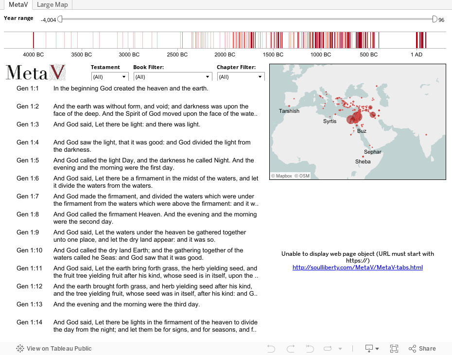
MetaV Explorer

We have come a long way from the days when you had to choose between an unwieldy Bible atlas or else limit yourself to a handful of maps in the back of your everyday Bible. With the proliferation of free online mapping tools hosted by Google, Yahoo, MapQuest, and others, we have the ability to overlay practically any information we want onto satellite imagery or simple region outlines. Naturally, some industrious Christians have incorporated some of the information from that old atlas into interactive maps.
One of these is BibleMap.org which does a great job of helping you explore the places mentioned in a particular chapter of the Bible that you may be reading or studying at the time. Another approach is that of OpenBible.info which allows users to download place marks for Google Earth, either for the entire Bible or individual books. One limitation of each of these is that it is either difficult or impossible to see every place all at once without downloading additional software.
That’s going to change right here, right now. Thanks to a powerful tool called Tableau Public recently made free for limited use on open-source data, we can download a file from a site like OpenBible.info and make some interesting comparisons. We can vary the colors and sizes of each place mark, filter for a particular place or book, and much more that can help us discover new insights or rediscover old ones. For example, the New Testament more heavily references northern regions and … wait a second! Since when was Spain referenced in the Bible? And, just where are Gog and Magog, anyway?
Here are a few tips for exploring the information. Click the legend to show only New or Old Testament references. Hover over a place mark to see more info, or click on it to see all the references associated with that place. Click-and-drag to select more than one place. Use the arrow icon at the bottom to allow for zooming and panning around the map. Choose one or more books for other filter options. Click the name of a place in the data sheet to reveal its location on the map. Most of all, have fun seeing the Bible in a whole new way! Note: the map may take a while to load.
There are a few things to bear in mind, however. First, the country divisions on this map correlate to present boundaries, not the boundaries as they were in the past. Bodies of water or whole countries are shown as a single place mark, which can make things somewhat difficult to interpret. I did not compile the original data, but as near as I can tell it is limited to explicit references of a place by name; it does not include verses which describe an event which took place in a particular location but doesn’t mention the place by name. Lastly, places mentioned during a time period before Noah’s flood are not shown since the global flood would have reshaped the landscape enough to make its location impossible to accurately identify.
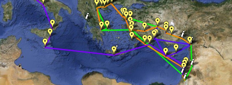
View Paul’s Life and Journeys in a larger map
While you explore the map above, below are some observations to take note of.
If the Lord has shown you something interesting that’s not in this list, we’d love for you to tell us about it!
Source info: Biblestudy.org (not affiliated with this website)